Dean & Ginny's excellent adventures...  Main Adventure Page

World Cruise2015: << Part 1 Part 2 Part 3 >> Part 4 >> Part 5 >> Part 6 >> Part 7 >> Part 8 >> Part 9 >>  
Part 10 >> Part 11 >> Part 12 >> Part 13 >> Part 14 >> Part 15 >> Part 16 >> Part 17 >> Part 18 >> Part 19 >> Part 20 >>  
Part 21 >>
Part 22 >> Part 23 >> Part 24 >> Part 25 >> Part 26 >> Part 27 >>  Part 28 >>  Part 29 >>  Part 30 >>  Part 31 >>
Part 32 >>  Part 33 >>  Part 34 >>  Part 35 >>  Part 36 >>  Part 37 >>  Part 38 >>  Part 39 >>

Santa Marta, Colombia (Itinerary)  

After 3 days at sea, this is our first stop. What a great way to start our adventure.


A lighthouse on a rocky island guards this port city. It is the oldest one in South America.

 
We thought that the side panels on the lighthouse were solar, but once the sun came up we could see that they weren't. The sunrise spoke to us...


We had to wait for this container ship to vacate our berth before we could dock. The lighthouse island looked like a desert once the sun was on it.


The tour buses and port shuttle buses were waiting for us as were the police.

 
The gateway to the port was made from a shipping container. Our plan for the day was to take a bus to Taganga, a small fishing village up the coast. The policeman tried to convince us that we should take a taxi (for $10), but when we refused, he escorted us for a couple of blocks toward the road where the public buses run because he said it was a dangerous neighborhood—too many prostitutes.


It looked like a normal neighborhood to us.


The policeman handed us over to another one for the last block or so.


People were carrying on their morning business. We think the sign indicates that this business will install triple-paned windows, closets, kitchens, and more.

    
We found the right bus and the driver said he would take our dollars—$1 each. The fare is normally about 65 cents in Colombian Pesos, but we did not ask for change.


The bus stopped at this building under construction which used a swirling pattern of rocks interspersed with wine bottle bottoms to let in light.


In Taganga there were all types of signs to commercial enterprises on the pole where the driver let us off. He pointed us to his left for the playa (beach).


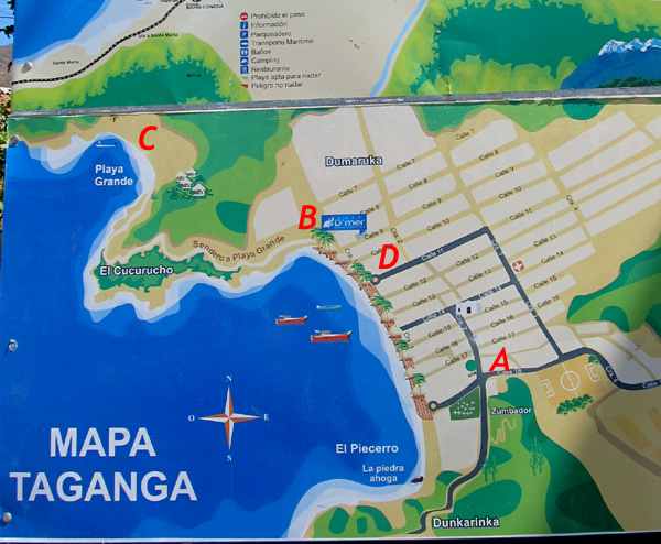
Later we found this map. I've marked it with red letters for orientation. The dark blue roads indicate the bus route. We got off the bus at A. We walked to the beach and then headed toward B.


Barrels of water were on top of buildings for pressure. A builder works on a cantilevered platform. With no air conditioning, people occupy their opened windows for the breeze.


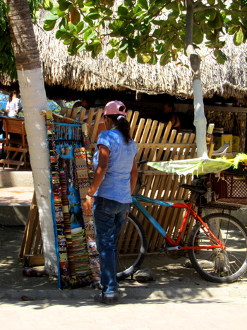
Beachside restaurants and bars are all under thatched roofs.


Looking across the beach toward the white hotel built into the side of the hill—B on the map. 


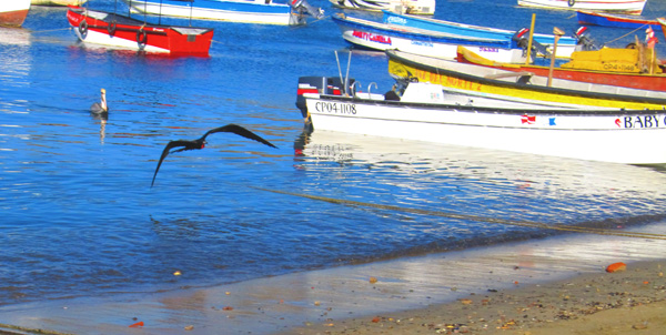
Many frigate birds and pelicans swooped overhead.


Dugout canoes certainly have character.

 
There are some dive shops in this town.

 
These fish were used as chum for the dive operators. Why the guy is wearing a motorcycle helmet was a mystery to us.


As we reached the far side of the beach, locals were waiting for boat rides. We found a small grocery store where the clerk would exchange $20 for pesos. When we asked about public restrooms, she directed us to the hotel. 


The restrooms were located near the pool-side restaurant. There is a great view of the beach from here. We also loved this beachy hanging there. Next to the hotel, there was a path that some people were taking, so we followed suit.

 
The trail included some tires for steps near the hotel, but farther on, there was little separating us from the cliff.


Finally we could see the other side of the mountain, La Playa Grande—C on the map.

  
The path became more civilized as we got closer to the beach.

 
An eco resort invites us in with its fancy railings and beach stone walls, but we don't realize how big it is until we got down to the beach and looked back.


How fanciful...


This is where the locals play.


After walking to the end of La Playa Grande and back, we climbed back over the hill toward Taganga. People on the trail were so friendly! Many young men climbed the hill with coolers of cold drinks to sell. We wondered about the economics of that effort.

 
We'd seen this cinderblock building on the way over. 

 
Beachside vendors

 
We'd not seen religious statues in cages before.

 
This mural is trying to encourage people not to pollute the marine ecosystem, because without it they have nothing.

 
There is one church in Taganga and one cemetery.


While the police were not as thick as in Santa Marta, they are still quite evident. This iceman uses a motorcycle pickup truck for his deliveries.


While waiting for the bus back to town at D on the map, a collectiv (a licensed, owner-operated 12-passenger van) stopped for us.  The side door is never closed, so I took this photo of another type of bus as it passed by. A diverse group of people were collected on the way back to Santa Marta until people, except for us, were piled on top of each other. 

   
We told the driver that we wanted to see the local market, so he pointed us in the right direction as even more people boarded with their loads from the market. It's always interesting to see how the locals function. These fish were laid open on a sheet of brown paper to dry.  


Most of the architecture is unremarkable, but there were a few interesting buildings. This is a government building.

 
A good sized church was holding mass.

 
This man was selling doughnuts and had extra stock balanced on his head.

 
While the lime slushy looked good, we opted for cold beers. Aguila is a local brand.

  
Simon Bolivar is the great liberator of Colombia from Spanish rule.


This modern, blue building near the port was completely covered with darker blue squiggles.

 
Rodrigo de Bastidas was the founder of this city. In addition to the statues along the malecón (wide sidewalk next to a beach), a market was set up in a series of white tents especially for tourists. We did walk through, but did not purchase anything. Too touristy. 


A swirling brick pattern makes the sidewalks here more inviting. 

What a day we had! All told, we walked almost 9 miles. We have a pedometer app on our smart phones, which we both run and average the readings for our total. On our other cruises, we knew we were walking a lot, but could only guess—now we'll know. Dean's log: Manta.

On to The San Blas Islands... >>

Main Adventure Page

Top of page:

© Sky-Bolt Enterprises 2001-2015